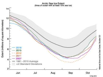
Arctic sea ice extent is the second lowest in the satellite record beginning in 1979. Although the vagaries of storms and wind affect the amount of sea ice that survives summer melting, it is clear that increased warming in the region is responsible for most of the decline. The National Snow and Ice Data Center reports:
Arctic sea ice appears to have reached its seasonal minimum extent for 2016 on September 10. A relatively rapid loss of sea ice in the first ten days of September has pushed the ice extent to a statistical tie with 2007 for the second lowest in the satellite record. September's low extent followed a summer characterized by conditions generally unfavorable for sea ice loss.
NSIDC
On September 10, Arctic sea ice extent stood at 4.14 million square kilometers (1.60 million square miles). This appears to have been the lowest extent of the year and is tied with 2007 as the second lowest extent on record. This year's minimum extent is 750,000 square kilometers (290,000 square miles) above the record low set in 2012 and is well below the two standard deviation range for the 37-year satellite record. Satellite data show extensive areas of open water in the Beaufort and Chukchi seas, and in the Laptev and East Siberian seas. …
Why did extent fall to a tie for second lowest with 2007? The 2016 Arctic melt season started with a record low maximum extent in March, and sea ice was measured at record low monthly extents well into June. …
The late season ice loss appears to have been greatest in an extended area of patchy ice reaching from the eastern Beaufort Sea to the northern Chukchi Sea. This is in the area influenced by the two strong cyclones … —the strong winds appear to have compacted the ice cover and may have led to an upward mixing of warm ocean water.
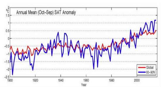
Last December, a report from researchers associated with the National Oceanic and Atmospheric Administration on Arctic temperature trends reported that "the mean annual surface air temperature anomaly (+1.3°C relative to the 1981-2010 mean value) for October 2014-September 2015 for land stations north of 60°N is the highest value in the record starting in 1900. This is an increase of 2.3°C since the 1970s and 2.9°C since the beginning of the 20th century. The global rate of temperature increase has slowed in the last decade (Kosaka and Xie 2013), but Arctic air temperatures have continued to increase. Currently, the Arctic is warming at more than twice the rate of lower latitudes."